
Mount Rinjani
On the map
There is no usable signal on most of the Rinjani trek or down in the caldera. Senaru and Sembalun villages have 4G, so do your connected work before you start walking.
What Mount Rinjani is
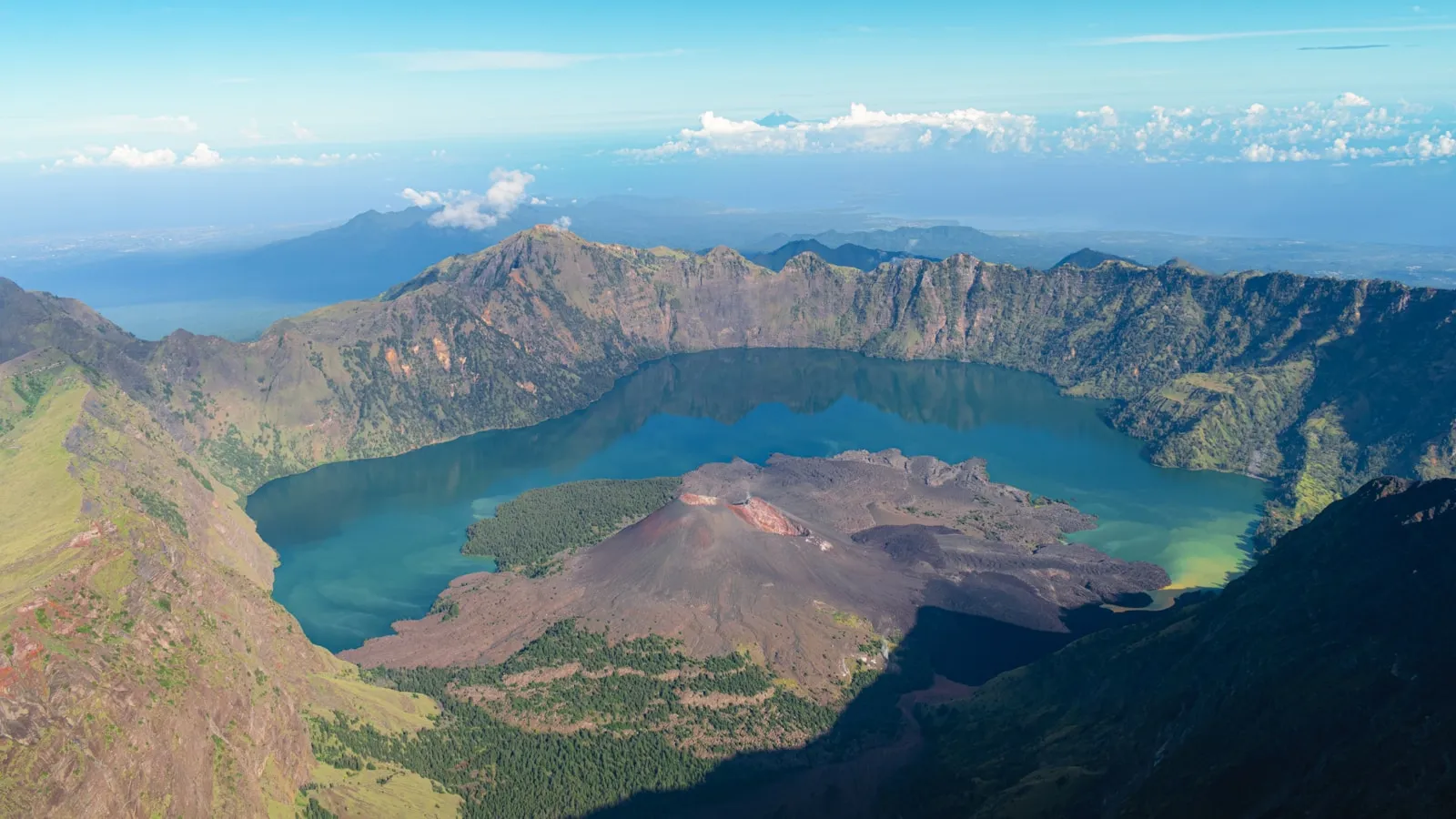
Mount Rinjani is an active volcano in northern Lombok and, at 3,726 metres, the high point of the island and one of the highest peaks in Indonesia. It sits inside Gunung Rinjani National Park, which also forms part of a UNESCO Global Geopark. The mountain's defining feature is its caldera, a vast collapsed crater holding the crescent lake Segara Anak, with the younger cone of Gunung Barujari rising out of the water. Rinjani is genuinely active and has erupted within living memory, so the park's status can change at short notice.
Permits, guides and quotas
Every climb needs a park permit booked through the national park's online system, and you must trek with a registered guide. Entry is capped by a daily quota per route, so places on popular dates go well before you arrive, and turning up at the gate hoping to join something is not a plan. A park entry fee applies, and it has been revised more than once, so confirm the current amount and the accepted payment method through official park channels rather than an older write-up. Trails also close during the wet season, with the dates announced season by season, so check the park's current status before you book flights around a climb.
The routes from Senaru and Sembalun
Two villages carry almost all Rinjani traffic, Sembalun on the east side and Senaru in the north, and most itineraries run two or three days between them. Sembalun starts across open grassland and gives the shorter, more direct approach to the crater rim and the summit. Senaru climbs through forest and is the wetter, shadier side. A common shape is up from Sembalun, a night on the rim, a pre-dawn summit attempt, then down past the lake and out at Senaru. The Torean route on the north side is a rougher alternative used mainly to reach the lake.
The summit push and the crater lake
The summit is the hardest part of the trek by a wide margin: a pre-dawn start on loose volcanic scree where you slide back with every step. Groups commonly leave the rim camp at around 2am to reach the top for sunrise, and the climb often takes three to four hours up for far less coming down. On the other side of the rim, Segara Anak lies in the caldera with hot springs a short walk from the shore, and plenty of trekkers rate the lake above the summit. Reaching it means a steep descent and an equally steep climb back out.
How hard the trek really is
Rinjani is a demanding multi-day trek, and what turns people back is usually cold and loose ground rather than distance. Nights on the rim are close to freezing and windy, the trail is steep and slippery in both directions, and the daytime sun on the exposed grassland is punishing. Bring broken-in boots with grip, a warm layer and a windproof one, a head torch, sun protection and more water than feels necessary. Porters carry the group camping equipment on most trips. If you have knee trouble, the descent is what will find it.
Phone signal on Rinjani
Expect no usable signal for most of the trek, including down in the caldera, and no eSIM changes that. As of July 2026, Senaru and Sembalun villages have workable 4G, and Goodbars runs on Telkomsel, which reaches further across Lombok than any other Indonesian network. On the mountain itself, coverage runs from unreliable to absent: a bar may appear on an exposed ridge and vanish a minute later, and at the lake there is nothing to depend on. Treat the trek as offline. Download maps, send what matters and leave your route with someone while you are still in the village, and carry a power bank, because cold drains a phone battery fast.
Common questions
Do you need a guide for Mount Rinjani?
Yes. A registered guide is required, along with a park permit booked through the national park's online system. Independent climbing is not permitted, and quotas cap how many people start each route per day.
How high is Mount Rinjani?
The summit is 3,726 metres, which makes it the highest point on Lombok and one of the highest peaks in Indonesia. The crater rim, where most groups camp, sits several hundred metres below that.
How many days does the Rinjani trek take?
Most itineraries are two or three days, typically starting at Sembalun and finishing at Senaru. Shorter rim-only trips exist, and reaching both the summit and the crater lake realistically needs three days.
How hard is the climb to the Rinjani summit?
Hard. The final push starts before dawn on loose volcanic scree that slides underfoot, usually takes three to four hours, and is cold and windy at the top. Good fitness and proper footwear matter more than technical skill.
Is Mount Rinjani open all year?
No. The park closes the trails during the wet season and announces the dates season by season, so check the park's current status before booking flights. Closures can also follow volcanic or weather warnings at short notice.
Is there phone signal on Mount Rinjani?
Not in any usable way. Senaru and Sembalun have 4G, but on the trail and in the caldera you should expect nothing, and no eSIM changes that. Download offline maps and send your messages before you set off.


Out exploring?NEVER LOST
Maps, rides and bookings that just work, all over the island. Plans from €13.99.
See the plans- No ID needed
- No contract
- Instant email delivery
- Works on arrival